An update on the Samsung browser and our maps

Recently, the Samsung Internet browser application was updated with new features which broke its compatibility with our site. The browser has an AI-driven privacy feature which strips out some very necessary tracking data from the technology we use to deliver our live maps.

A big thank you to @MalcolmA73 on Twitter who has discovered that turning off the smart anti-tracking functionality fixes the problem.

For the technically minded, the problem is that the browser views the URL for our Websocket server, which includes a unique value in the URL for each connection, as a privacy concern. This isn’t really true in our view – the unique value allows us to send the right data to the right browser, and is actually less intrusive than tracking by IP address and TCP port number.

We’re working on a feature that will automatically identify if you’re trying to use our maps from a Samsung browser and display some information on how to disable the privacy feature for our website. If all goes to plan, this should be in the update on Sunday 22nd May 2022.

May bug-fixes and Samsung browsers on Android

This week, we’ve been busy looking at a problem with the Samsung Internet browser continually trying to connect to our maps. At the moment, we’re unsure what the exact problem is – if you’re affected, please use another browser for the time being, such as Chrome or Firefox (other browsers are available). For the technically minded, when the Samsung browser connects to our load balancer, it seems not to upgrade the HTTPS connection to a Websocket connection properly, and we’re not sure why.

Since we’ve been preoccupied, there’s only a bunch of minor updates to announce:

  • We’ve updated the North Kent Line map to add the connection in to the Crossrail Core east of Abbey Wood
  • We’ve tidied up Fawkham Junction, adding signal and route indications
  • The signal and route indication problem with the Crewe – Shrewsbury map is no longer present, so we’ve removed the warnings and drawn in further router indications
  • Signals at Littlehampton were shown as colour-light signals, but are in fact semaphore signals. We’ve updated our map to make this clear, and adding BH72 signal at Arundel which was missing
  • The two junctions at Tonbridge are now labelled East and West, and not both the same name, defying the compass
  • Routes from T560 signal at Purley were incorrectly drawn in to platform 4, rather than platform 5 as they are in reality
  • As well as fixing the name of Castle Donington siding on the Sheet Stores Junction map, we’ve added in East Midlands Gateway which was built after the maps we were working from. We also have routes around Trowell and Ilkeston Junctions
  • Some routes at Leicester weren’t indicating correctly, so we’ve fixed these
  • The routes from WK802 at Woking were incorrectly drawn due to a mis-positioned crossing, which we’ve resolved
  • At Clay Mills Junction, routes were showing incorrectly from signal 184, and routes were also showing incorrectly at Burton-on-Trent and Leicester Junction
  • Platform 1 at Retford is now drawn in the right place

And finally – to everyone who’s asked when our Crossrail/Elizabeth Line/Purple Train map will be available… it’ll be the day before the line officially opens to the public.

May 2022 update

This evening, we released a new version of the site with lots of updates to maps:

  • Our coverage now extends through Telford Central on the new Oxley area map. This map is slightly unusual in that it has additional berths without signals at Telford, used for reporting train movements to TRUST
  • The Northern City Line is being re-signalled over the weekend, with ETCS marker boards and very little change to signal positions. We’ve updated our map accordingly so you can watch the commissioning take place
  • The new crossovers at Leeds are shown on, unsurprisingly, our Leeds map. We’ve also taken the opportunity to finish adding route indications to the rest of the map, which is no easy task
  • The North Kent East map now has route indications at St Johns, Lewisham and Lewisham Vale Junctions, Parks Bridge Junction and Courthill Loop Junctions
  • We missed the resignalling at Trafford Park, so our Salford area map has only just been updated. Trains between Castlefield Junction and Urmston are now showing correctly
  • We also added route indications at Otford Junction
  • The GNGE map has been slightly extended past Retford Low Level toward Worksop

As always, there are a bunch of other minor things we’ve fixed that you’ve reported – missing crossovers, signals in the wrong position, incorrect map labels. Please remember to report any issues using the support email address. We log everything we get there, and it can’t get lost in somebody’s inbox.

April 2022 update

It’s been a while since we updated the blog – there have been releases and updates since our last post, and we’ve just not posted about them. We’re going to cover this week’s updated.

We have a new map of the Burton-on-Trent area. This new map covers, amongst other parts of the railway, Central Rivers Depot, Hams Hall and Tamworth Low Level. It will join up with other maps in due course covering Washwood Heath and Walsall.

Network Rail’s Feltham and Wokingham Resignalling Programme is about to complete Phase 2, with control of the Ascot area moving over to a new control system at Basingstoke ROC. We’ve updated several of our maps to show this.

Finally, we’ve just released updates to the site to add in the crossings at Watford North Junction which aren’t being brought in to use just yet, but will be in the future.

Please remember to report problems with the maps to support@opentraintimes.com so we can fix them and importantly, let you know when they’re fixed.

October 2020 Update

We’re a couple of weeks behind on getting our October update tested and live, but when you see the updated Euston to Wembley Central map, you’ll understand why it’s taken so long!

Network Rail have enabled signal aspect and route setting data for the rest of Wembley Mainline SCC. That’s both the Willesden Surburban WestCAD, controlling the “DC Lines” from Watford Junction to Camden Junction, and some of the signalling for Wembley Yard. The WestCAD workstation controlling Wembley Central to Kings Langley and St Albans Abbey was already outputting this data, and we’ve had this since early 2015.

That’s the big one – we’ve also extended the Guildford map to Aldershot South Junction and made some fixes to the Wakefield Kirkgate map. We’ve also added the St Albans Abbey branch line to our Wembley to Tring map. This will show train movements in the near future.

In case you missed it, we’ve also been busy working on a data-driven approach to train maintenance, and we blogged about it a week or two ago. Taking on work such as this helps us keep the public site free.

Until next time, keep safe and wear a mask!

Improving train maintenance with real-time data

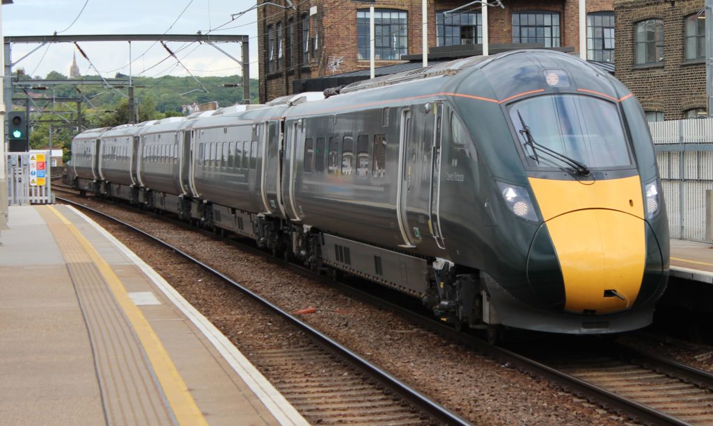
We’ve been busy over the last six months, working closely with Iotics and Rolls-Royce Power Systems (RRPS) on a project to help improve the reliability of Class 80x trains.

A 5-car Class 800 train, named Queen Victoria, in Great Western Railway livery passing through Kentish Town West ation
Rsa, CC BY-SA 3.0 http://creativecommons.org/licenses/by-sa/3.0/, via Wikimedia Commons

Rolling stock needs regular maintenance to keep it running smoothly. Many faults are not urgent and can wait until the stock next undergoes maintenance. But some faults are a priority and need fixing within a day or two, otherwise the stock may be unable to enter service the next day or, worse, fail in service and cause delays. Both of these cause disruption to the railway, negatively impacting the customer experience.

Control teams are experienced at juggling available train crew and rolling stock to keep the planned service running, but what happens when rolling stock deviates from its diagram, and that stock needs equipment swapped at a particular depot overnight? Trains can end up at the wrong depot, or enter in reverse formation, causing operational problems and risking cancellations the next day.

To solve this problem, we combined our deep knowledge of railway operations and real-time data analysis with Iotics Digital Twin ecosystem, Iotic Space, which lets us securely access a ‘twin’ of sensor data on each Class 80x train. When we detect that a train will no longer end its day at the right depot at the right time, we send an exception message through Iotic Space which alerts the Central Planning Cell and updates a Depot Dashboard in good time for staff to make a decision on what to do.

Our technology isn’t limited to the Class 80x fleet, and we’re able to roll it out to other operators’ fleets without many changes.

To see how we can help improve the reliability of your rolling stock, contact Sophie Peachey at Iotics. To talk about how we can help your operations using real-time data, contact Peter Hicks at OpenTrainTimes.

September 2020 Update

Well, that was a summer and a half. Several months not travelling anywhere by train, plenty of cycling and some really hot weeks. The founder of the site, Peter Hicks, recorded a video with Geoff Marshall about the site – warning: it includes a very lovely Italian Greyhound. Go check out out.

Since our last big update in April, we’ve made numerous updates to the site. But first, September’s update. We proudly unveil a new map covering Wakefield Kirkgate to Castleford, Knottingley and Hensall. It covers Drax and Eggborough Power Stations, Knottingley, Castleford and Hunslet and Stourton freight terminals near Leeds.

We also released another new map of Salford (Manchester), covering the boundary with Rochdale and Stalybridge, Manchester Victoria, Salford and the two routes to Crow Nest Junction and Warrington Central.

In due course, we’ll extend other maps to link up with these.

As for the minor updates, we’ve added some signals, additional route indications and fixed some smaller bugs. This takes a lot of time – all our maps are are drawn by hand. Whilst this takes time, we’re frequently told they are more complete and look better than other sites offering the same service. If you’re one of the people who’ve been in touch to say that – thank you, we really appreciate the feedback.

Work continues on a new version of the site. We’re involved in a number of industry projects which are helping to build new components. We’re also working with the Emergent Alliance on the post-COVID-19 recovery of the rail industry, and hopefully there will be some data off the back of that which we can share.

Finally, several people have asked why we don’t show train formations, as some other sites do. The simple answer is that the data isn’t open, and we don’t want to work on a way of getting it for just us. Why shouldn’t everyone benefit? Watch this space though.

There will be more regular updates over the next few months, and more maps. In the meantime, watch this space, follow us on Twitter and Facebook so you’re up-to-date with what we’re doing.

April 2020 Update

Just in time for the end of the month, and we’re back with the updates that have taken place on the site over the past few weeks.

Keep safe and remember – don’t travel unless it’s absolutely necessary.

March 2020 Update

The world has changed dramatically since our last update, but we’re still here and open for business. Substantially fewer people have visited the site over the past weeks, but since we don’t rely on advertising or subscriptions, there’s no danger of us going away any time soon.

We are also offering pro bono services to the rail industry during this difficult period. If we can help you in any way, please email hello@opentraintimes.com.

Despite everything that’s going on right now, we’ve been beavering away at the site and we’ve just released our slightly late March update. Here are the highlights:

February 2020 update

We’ve just made a massive update to the site, with bugs squashed left right and centre. It’d take too long to go through everything we’ve done, but here are the important highlights: